2012 was Warmest and Second Most Extreme Year on Record for the Contiguous U.S.
The average temperature for 2012 was 55.3°F, 3.2°F above the 20th century average, and 1.0°F above 1998, the previous warmest year.
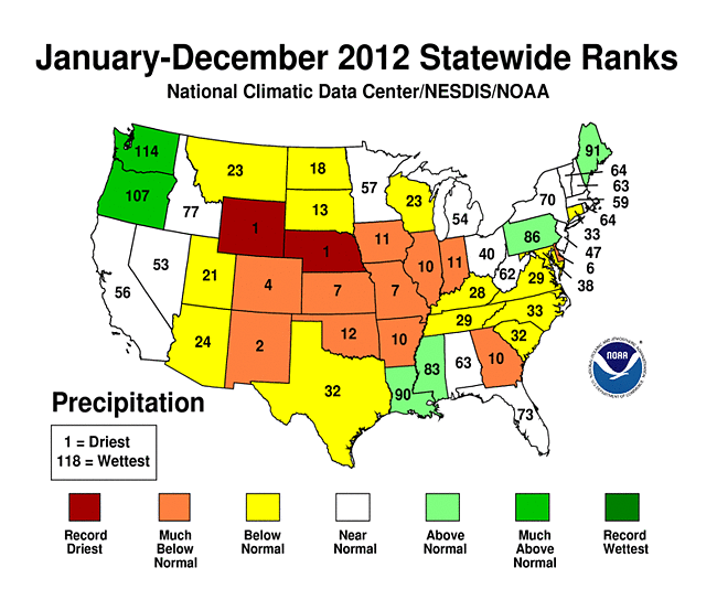
The average precipitation total for the contiguous U.S. for 2012 was 26.57 inches, 2.57 inches below average, making it the 15th driest year on record for the nation. At its peak in July, the drought of 2012 engulfed 61 percent of the nation with the Mountain West, Great Plains, and Midwest experiencing the most intense drought conditions. The dry conditions proved ideal for wildfires in the West, charring 9.2 million acres — the third highest on record.
The U.S. Climate Extremes Index indicated that 2012 was the second most extreme year on record for the nation. The index, which evaluates extremes in temperature and precipitation, as well as landfalling tropical cyclones, was nearly twice the average value and second only to 1998. To date, 2012 has seen 11 disasters that have reached the $1 billion threshold in losses, to include Sandy, Isaac, and tornado outbreaks experienced in the Great Plains, Texas and Southeast/Ohio Valley.
Note: The Annual Climate Report for the United States has several pages of supplemental information and dataregarding some of the exceptional events 2012.
U.S. temperature
-
2012 Statewide Temperature (top) ranksEvery state in the contiguous U.S. had an above-average annual temperature for 2012. Nineteen states had a record warm year and an additional 26 states had one of their 10 warmest.
- On the national scale, 2012 started off much warmer than average with the fourth warmest winter (December 2011-February 2012) on record. Winter warmth limited snow with many locations experiencing near-record low snowfall totals. The winter snow cover for the contiguous U.S. was the third smallest on record and snowpack totals across the Central and Southern Rockies were less than half of normal.
- Spring started off exceptionally warm with the warmest March on record, followed by the fourth warmest April and second warmest May. The season’s temperature was 5.2°F above average, making it easily the warmest spring on record, surpassing the previous record by 2.0°F. The warm spring resulted in an early start to the 2012 growing season in many places, which increased the loss of water from the soil earlier than what is typical. In combination with the lack of winter snow and residual dryness from 2011, the record warm spring laid the foundation for the widespread drought conditions in large areas of the U.S. during 2012.
- The above-average temperatures of spring continued into summer. The national-scale heat peaked in July with an average temperature of 76.9°F, 3.6°F above average, making it the hottest month ever observed for the contiguous United States. The eighth warmest June, record hottest July, and a warmer-than-average August resulted in a summer average temperature of 73.8°F, the second hottest summer on record by only hundredths of a degree. An estimated 99.1 million people experienced 10 or more days of summer temperatures greater than 100°F, nearly one-third of the nation’s population.
- Autumn and December temperatures were warmer than average, but not of the same magnitude as the three previous seasons. Autumn warmth in the western U.S. offset cooler temperatures in the eastern half of the country. Although the last four months of 2012 did not bring the same unusual warmth as the first 8 months of the year, the September through December temperatures were warm enough for 2012 to remain the record warmest year by a wide margin.
U.S. precipitation
- The nationally-averaged precipitation total of 26.57 inches was 2.57 inches below average and the 15th driest year on record for the lower 48. This was also the driest year for the nation since 1988 when 25.25 inches of precipitation was observed. Each season of 2012 had precipitation totals below the 20th century average:
- Winter brought below-average precipitation to both coasts and above-average precipitation to the Southern Plains, slightly lessening drought conditions that plagued the region in 2011. The winter precipitation total was 89 percent of normal.
- Spring precipitation was 95 percent of the 20th century average with below-average precipitation in the Rockies and Midwest and above-average precipitation in the Northwest and Upper Midwest.
- Summer precipitation was 88 percent of normal with dry conditions in the central United States. The West Coast, Gulf Coast, and Northeast were wetter than average.
- Autumn was drier than average for most of the central U.S., with wet conditions in the Northwest, Ohio Valley, and Northeast. The autumn precipitation total was 85 percent of average.
Alaska and Hawaii
- Alaska was cooler and slightly wetter than average during 2012. The year began very cold for the state with a January temperature 14.0°F below the 1971-2000 average. Each subsequent season was also cooler than average, resulting in an annual temperature 2.3°F below average. Much of 2012 was also wetter than average, and the annual precipitation total was 9.2 percent above average.
- Drought conditions continued to plague Hawaii during 2012. At the beginning of 2012, 47.4 percent of the state was experiencing moderate-to-exceptional drought, according to the U.S. Drought Monitor. By the end of the year, the percent area experiencing moderate-to-exceptional drought expanded to 63.3 percent of the state.
Significant weather and climate events

Significant weather and climate events for 2012.
Click image to enlarge, or click here for the National Overview.
- Tropical cyclone activity across the North Atlantic in 2012 as above-average with 19 named storms, ten hurricanes, and one major hurricane (Category 3 or stronger). This is the third consecutive North Atlantic tropical cyclone season with 19 named storms and ties with as the third most active season for the basin. Isaac and Sandy made landfall along the U.S. coast during 2012 causing significant impacts. Isaac brought large storm surge and torrential rains to the Gulf Coast. Sandy caused significant damage to the Northeast, with 8 million homes losing power and 131 fatalities reported.
- The widespread drought conditions of 2012 peaked in July with approximately 61 percent of the country experiencing drought conditions. The footprint of drought during 2012 roughly equaled the drought of the 1950s which peaked at approximately 60 percent. The size of the current drought and the drought of the 1950s are smaller than the drought episodes of the 1930s. The current drought has yet to reach the intensity or duration of the 1950s and 1930s national-scale droughts.
- Wildfire activity during 2012 was above-average with 9.2 million acres burned the third most in the 13-year record. Numerous large and destructive wildfires impacted the western U.S. throughout the year. The Waldo Canyon fire near Colorado Springs, Colorado destroyed nearly 350 homes and was the most destructive fire on record for the state. The Whitewater-Baldy Complex fire charred nearly 300,000 acres and was the largest on record for New Mexico.
- Tornado activity during 2012 was below the 1991-2010 average of approximately 1,200. The year got off to a busy start with large tornado outbreaks in March and April causing significant damage in the Ohio Valley and Central Plains. May and June, typically the most active tornado months of the year, both had less than half of average tornado counts. The final 2012 tornado count will likely be less than 1,000 — the least since 2002.


